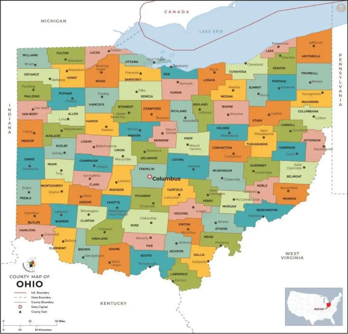
An Ohio County Map is a valuable resource for exploring the 88 counties that make up the state. Whether you're studying local government, planning a road trip, conducting genealogical research, or learning about Ohio’s geography, this map provides clearly defined county boundaries and highlights major cities and towns. It serves as an essential tool for understanding the state's regional layout and navigating its diverse communities.

An Ohio County Map helps users understand how the state's counties are connected and how they relate to major geographic features such as the Ohio River. It also makes it easy to locate important cities, including Cleveland, Columbus, and Cincinnati, along with the transportation routes that connect them. Whether used for education, travel planning, or local research, an Ohio County Map is a simple yet effective tool for gaining a better understanding of Ohio’s regional structure and geographic layout.
A Free Ohio Map with Cities is an excellent resource for quickly locating Ohio’s counties and major cities. The map clearly displays county boundaries and highlights key urban centers such as Cleveland, Columbus, Cincinnati, Dayton, and Toledo. Whether you're planning a trip, conducting research, supporting business activities, or studying Ohio’s geography, this map provides an easy-to-use visual reference for understanding the state's layout and regional connections.

Teachers often use a Free Ohio Map with Cities to help students learn about the state's geography and regional divisions, while families rely on it for planning road trips and exploring different destinations across Ohio. For professionals in real estate, logistics, and business, the map serves as a valuable reference for understanding the distribution of cities and their relationship to surrounding counties. Easy to access and download, a Free Ohio Map with Cities is a practical and useful resource for anyone interested in navigating or learning more about the state.
An Ohio ZIP Code Map combines county boundaries with postal ZIP code regions, making it an essential tool for managing mail delivery, business operations, and targeted marketing campaigns. By clearly displaying ZIP code areas alongside county lines, the map helps users identify specific locations and understand regional demographics. It is especially valuable for real estate professionals, delivery drivers, logistics companies, and businesses that require accurate geographic and market data for planning and decision-making.

An Ohio ZIP Code Map allows users to identify specific ZIP codes within each county, making it easier to plan sales territories, delivery routes, and service areas. It also helps residents determine which ZIP codes belong to their communities and neighboring regions. Whether you're organizing direct mail campaigns, conducting market research, analyzing demographic data, or managing logistics, an Ohio ZIP Code Map is a practical and valuable resource for accurate geographic planning and decision-making.
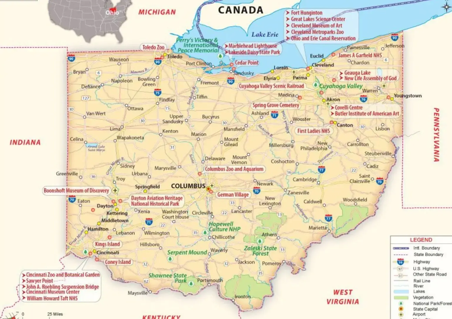
A Map of Ohio with Roads is an essential resource for navigating the state's highways, interstates, and local road networks. It clearly displays county boundaries along with major transportation routes, helping travelers plan efficient and convenient journeys. For businesses, truck drivers, logistics providers, and emergency services, this map offers valuable guidance by highlighting the most effective routes across Ohio. Whether for travel, transportation, or operational planning, an Ohio road map is a reliable tool for navigating the state with confidence.

Tourists can use an Ohio Road Map to discover scenic driving routes through the state's charming rural landscapes and vibrant cities. It is also a valuable resource for transportation planning, road construction projects, and regional development initiatives. Whether you're exploring new destinations, commuting, or planning long-distance travel, keeping a Map of Ohio with Roads in your vehicle can help ensure safer, more efficient, and well-informed journeys throughout the state.
